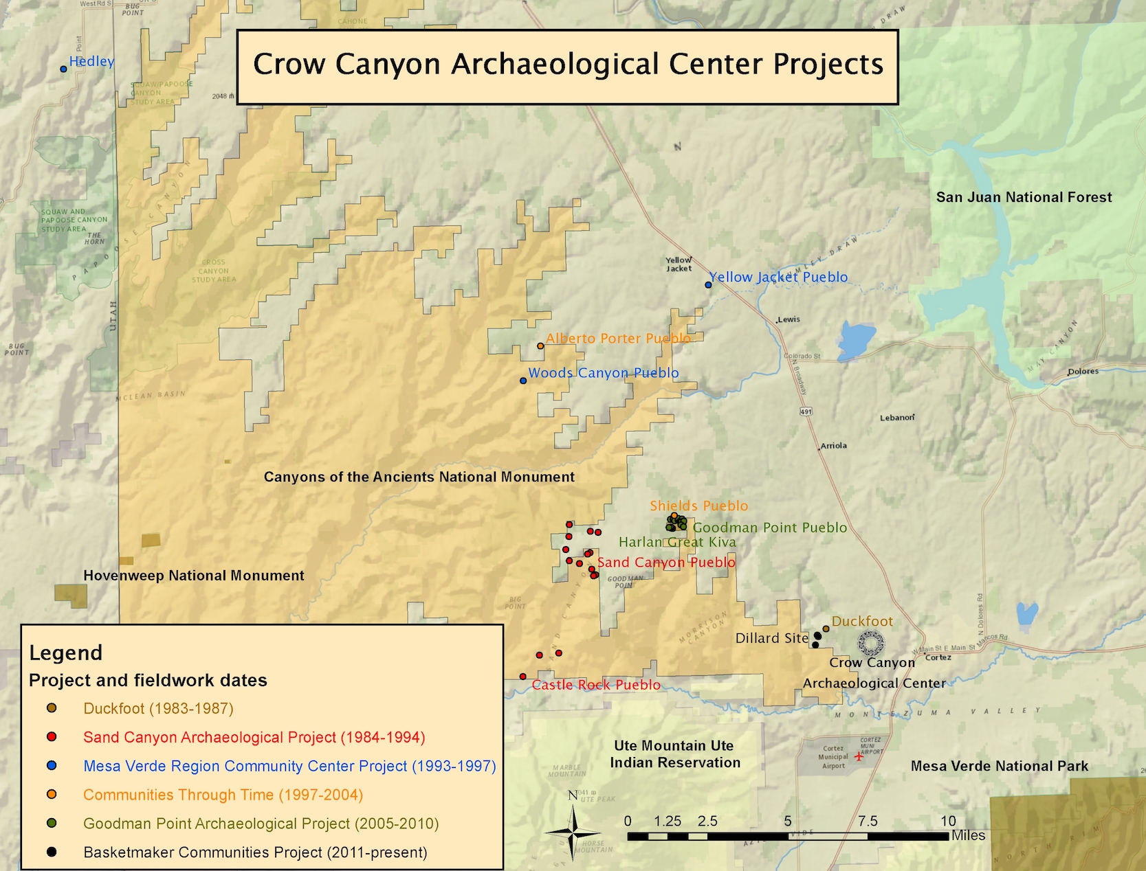
Active Projects at Crow Canyon
Ancestral Pueblo Maize Database
2019–now
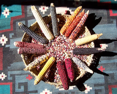
It is difficult to overstate the importance of maize to Pueblo people, whose ancestral homeland includes southwestern Colorado. For archaeologists, the introduction of maize agriculture marks the beginning of Pueblo society. Similarly, Pueblo oral history ties their origins to the adoption of maize agriculture. As part of the Ancestral Pueblo Maize Database project, the Research Institute at Crow Canyon and the Hopi Cultural Preservation Office are building the first-ever comprehensive, publicly-accessible database of curated ancestral Pueblo maize. Through a series of workshops and museum visits, our team of Hopi scholars and archaeologists will assess connections between ancient maize and modern Pueblo varieties, and determine criteria that specimens must meet to be viable for future analyses. After filling data gaps on maize collections in Colorado museums, the team will develop a research design for a large-scale, multi-method analysis of ancient maize. This project is being paid for by a History Colorado — State Historical Fund grant and by generous donations to the Research Institute. Read our funded proposal to the State Historical Fund here.
Crow Canyon Digital Archaeology Tools and Access
2016–now
The Crow Canyon Digital Archaeology Tools and Access (CC-DATA) project will modernize Crow Canyon Archaeological Center’s research database to enable diverse forms of access for researchers, descendent communities, and the broader public. The project focuses on integrating legacy archaeological datasets recorded over the last 33 years with born-digital data such as drone maps, 3D laser scans, and digital photographs. This modern database will be deeply geospatial, and will enable connections to external collections databases. Building upon such a database, the CC-DATA project will develop digital humanities products such as richly-interactive data exploration tools and multivocal archaeology portals that blend Western and indigenous perspectives about the past. Crow Canyon has been a leader in completing archaeological research with the assistance of the public—this effort will invite the public to join in the co-creation of archaeological knowledge that is interdisciplinary, multicultural, and relevant in the 21st century. Read our recent proposal to the NEH here.
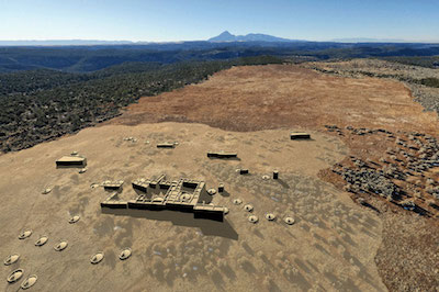
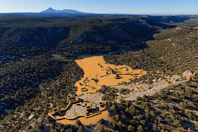
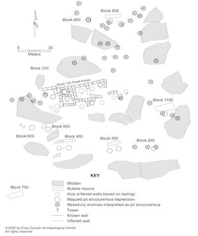
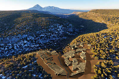
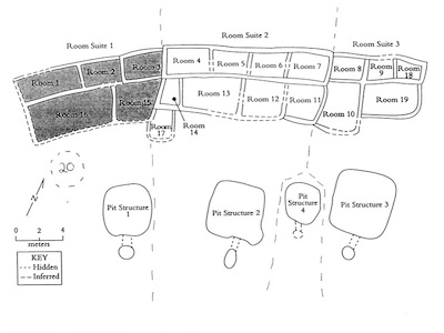
2016–now
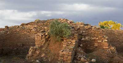
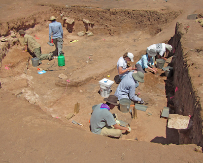
The Northern Chaco Outliers Project focuses on the Haynie site, a multi-component ancestral Pueblo village with two Pueblo II period (AD 950–1150) great houses located northeast of Cortez, Colorado. The great and small houses at the Haynie site were part of the larger Lakeview community, a 1 km² area comprised of the densest concentration of great houses found north of the San Juan River. Previous research in the Lakeview group and an initial assessment of the Haynie site during the 2016 field season suggests that the great houses were constructed above earlier architecture dating to the Basketmaker III and Pueblo I periods (AD 500–950). Excavation at the Haynie site will seek to determine precisely when the site was initially occupied, when it was subsequently depopulated, and how this related to other great houses located in the Lakeview community and the larger region. Data collected during the Northern Chaco Outliers Project will also allow contribute to a greater understanding of resource sustainability, the natural and cultural impacts of environmental downturns, ancient communities and regional systems, migration, and human/environment relationships.
The Effect of Crop Failure on Small Scale Village Organization
2015–now
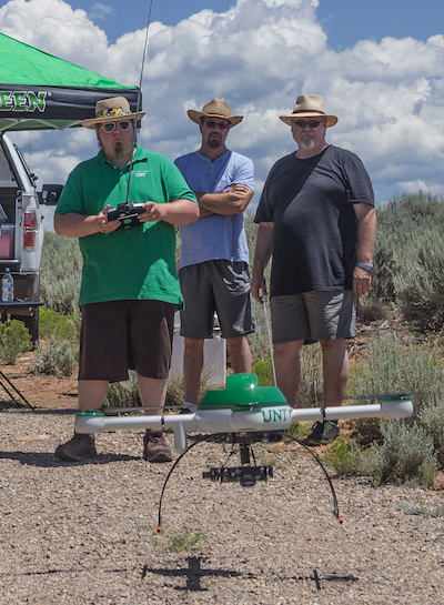
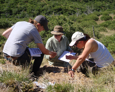
The Effect of Crop Failure on Small Scale Village Organization will study soils around Ancestral Pueblo villages in southwestern Colorado at a much finer resolution than ever before, asking, “during the latest occupations, when people moved to water sources and farther from their fields, what options and risks did they face in terms of farming opportunities?” This new project uses contemporary modeling approaches from surface hydrology to determine soil moisture potential in watersheds near villages. High-resolution images of landscapes around large villages will be obtained using an Unmanned Aerial Vehicle (UAV or “drone”). Together, these data will be used to assess the risk of maize crop failure by determining which soils have high and low potential for reaching the wilting point for corn. Maps will be produced so that these dynamics can be studied from the village looking outward at the scale that past farmers walked the landscapes they lived within.
2014-now
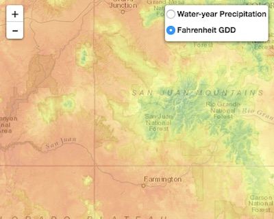
Synthesizing Knowledge of Past Environments (SKOPE) is an NSF-funded effort to bring paleoenvironmental data to researchers and the public through an intuitive, map-based user interface, and also to improve the capacity of researchers to do reproducible paleoenvironmental research. The project is a collaboration between Crow Canyon, Washington State University, Arizona State University, and the National Center for Supercomputing Applications at the University of Illinois, Urbana-Champaign. In response to a specific query, SKOPE will extract the latest data from diverse online databases. Using explicit and repeatable procedures, it will process the data to yield a cutting-edge synthesis of environmental information specifically tailored to the user’s request. Initially the tool will be developed for the Southwest US over the last 2000 years, but it will be designed to be readily extended to other places and times.
2011–now
Starting in 2011, Crow Canyon archaeologists, assisted by student and adult participants in the Center’s archaeology programs, began field investigations at selected Basketmaker III sites in Indian Camp Ranch. Because relatively little is known about this early chapter in Pueblo history―and because this was Crow Canyon’s first foray into Basketmaker archaeology―researchers had many questions. Where did the Pueblo people who first settled the central Mesa Verde region come from? How and why did early communities develop? What impact did a growing farming population have on the environment? And what are the environmental and social legacies of the Basketmakers on later Pueblo populations in the region?

2006–now
The Pueblo Farming Project is a collaboration between Crow Canyon and the Hopi Cultural Preservation Office to understand ancient maize (corn) agriculture in the Mesa Verde region through documenting traditional ecological knowledge, experimental gardens, and genetic analysis. Since summer of 2008, traditional Hopi farmers have traveled to Crow Canyon to plant maize gardens on the Crow Canyon campus. We’ve found that traditional varieties of Hopi corn, when planted using Hopi cultivation methods, grow well in the Mesa Verde region.
2001–now
The Village Ecodynamics Project (VEP) is a multidisciplinary collaboration among researchers at several different institutions to study the interaction between ancestral Pueblo people and their environment over more than a thousand years, beginning in AD 600. The VEP includes two study areas, one in southwestern Colorado and the other in northern New Mexico. Funded by National Science Foundation (NSF) grants awarded to Washington State University, the VEP employs an innovative approach to reconstructing the human past and exploring its relevance for today’s world. The VEP integrates three major studies: A reconstruction of the past environment; A computer simulation; and, An analysis of all known archaeological sites in the study areas. The VEP team included archaeologists, geologists, hydrologists, geographers, computer scientists, and economists from institutions across the U.S. and Canada. Between 2001 and 2014, this team completed a wide range of studies, and we continue to work on publications for both professional and public audiences. The VEP team also partnered with many other institutions and agencies, including the National Parks Service, National Forest Service, and Bureau of Land Management. Together, we compiled datasets and developed techniques that we believe will be invaluable to others for years to come.
Legacy Projects at Crow Canyon
The Goodman Point Archaeological Project
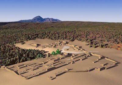
Reconstruction of Goodman Point Pueblo
by Dennis R. Holloway, architect; photo by Adriel Heisey
2005–2010
The Goodman Point Archaeological Project builds on the preceding community studies and involves excavations at the large village of Goodman Point Pueblo and surrounding smaller sites. Phase I of the study—Goodman Point Pueblo Excavations—was conducted from 2005 through 2008; it involved test excavations at Goodman Point Pueblo (Site 5MT604), the large village that served as the focal point of a large community in the late A.D. 1200s. Phase II of the project—Goodman Point Community Testing—involves test excavations at multiple smaller sites surrounding the large village, including a variety of habitation sites, an ancient road, and areas that might have been agricultural fields, as well as testing of the Harlan Great Kiva site. We are also investigating the relationship of Goodman Point to Sand Canyon Pueblo as one of the few (and, perhaps, only) multi-village polities in the region. The final report for the Goodman Point Archaeological Project is nearing completion.
Communities Through Time:
Migration, Cooperation, and Conflict
Reconstruction of Albert Porter Pueblo
by Dennis R. Holloway, architect; photo by Adriel Heisey
1997–2004
Communities through Time: Migration, Cooperation, and Conflict was a regional research project that examined the development and abandonment of ancient Puebloan communities in the Mesa Verde archaeological region from A.D. 900 to 1300, incorporating data gathered at the residential, community, and regional levels. The project included excavations at Shields Pueblo in the Sand Canyon locality and at Albert Porter Pueblo in the Woods Canyon locality. The excavations at Shields Pueblo were designed primarily to collect artifact and ecofact assemblages from residential structures occupied and abandoned between A.D. 1050 and 1225, the interval during which Shields Pueblo is thought to have been a focal location within the larger Goodman Point community. The focus of community-level research involves integrating Shields Pueblo into the larger framework of the surrounding natural environment and cultural landscape defined by the numerous prehistoric settlements surrounding both Goodman Point and Shields pueblos. Regional-level research compared the Goodman Point Community with 26 other, similarly long-lasting communities in the Mesa Verde region and other Mesa Verde-region community centers investigated by Crow Canyon. The overarching goal of the Albert Porter Pueblo excavations was to reconstruct the historic development of the village and the associated community. The resulting reconstruction identifies multiple periods of occupation, documents population growth and decline through time, and addresses the emergence of the settlement as a community center. The presence of a Chaco period great house and a dense cluster of associated smaller habitations suggest that Albert Porter Pueblo served as a community center. Crow Canyon’s research at Albert Porter Pueblo provides important new insights into the historical development, population dynamics, and human environmental impacts of ancestral Pueblo communities in the central Mesa Verde region.
The Village Testing Project
Reconstruction of Woods Canyon Pueblo
by Dennis R. Holloway, architect; photo by Adriel Heisey
1994–1997
Crow Canyon archaeologists designed the Village Testing Project to complement the Center’s earlier research in the nearby Sand Canyon locality. Our research in the Sand Canyon locality suggested that large villages had formed rapidly in the mid-1200s as people moved from small upland settlements to large villages in canyon environments. The Village Testing Project focused on the investigation of large, late sites outside the locality in an effort to determine whether this aggregation might have been part of a larger phenomenon in the central Mesa Verde region. The testing program conducted at Woods Canyon Pueblo and Woods Canyon Reservoir (Site 5MT12086) examined whether the changes through time in settlement patterns, subsistence practices, and the use of the cultural landscape that were identified in the Sand Canyon locality also occurred in the Woods Canyon community. Crow Canyon also conducted limited testing at Yellow Jacket Pueblo and the Hedley Site Complex.
The Village Mapping Project
1993–1995
In 1993, the Village Mapping Project was initiated to obtain detailed surfacial information about Pueblo II–III villages outside the Sand Canyon locality. Thirty villages were initially mapped using orthorectified aerial imagery. Six of the 30 centers were then chosen for intensive mapping, architectural analysis, and a chronological analysis of pottery sherds on the modern ground surface: Albert Porter Pueblo, the Bass Site Complex, Seven Towers Pueblo, Cannonball Ruins, Woods Canyon Pueblo, and Hedley Main Ruin.
The Sand Canyon Archaeological Project
Reconstruction of Sand Canyon Pueblo
by Dennis R. Holloway, architect; photo by Adriel Heisey
1983–1993
The Sand Canyon Archaeological Project studied settlement in the Sand Canyon locality, focusing on the A.D. 1000–1290 period. Beginning in 1983 and continuing to 1993, the Crow Canyon Archaeological Center conducted extensive archaeological investigations in an effort to better understand the ancient Puebloan communities of the mesa and canyon country west of Mesa Verde National Park. The research at Sand Canyon Pueblo (Site 5MT765) was a major component of the Sand Canyon Archaeological Project. This project also included intensive excavations at a small site (Green Lizard) and a medium-size site (Castle Rock Pueblo), probabilistically designed test excavations at numerous small sites, intensive survey of approximately 30 km2 in the Sand Canyon locality, and paleoenvironmental modeling. Several published accounts cover aspects of the history of research at Sand Canyon Pueblo in the context of the larger regional project. The 1992 Sand Canyon Archaeological Project progress report devotes a chapter to the excavations at Sand Canyon Pueblo, and various components of the larger project are described in other chapters. The Site Testing Program, which consisted of small-scale test excavations at 13 sites in the Sand Canyon locality, was an essential component of the larger project.
The Duckfoot Site
1983–1987
The Duckfoot site investigation was the first major research project to be undertaken by the Crow Canyon Archaeological Center. Field and laboratory studies were designed to increase our understanding of the prehistoric occupation of the area just to the west of Cortez, CO, during the mid- to late ninth century. The project was also where Crow Canyon’s educational goal of increasing public awareness, knowledge, and appreciation of the archaeological research process was developed and refined. The Duckfoot site remains one of the most thoroughly-documented and interpreted Pueblo I sites in the Central Mesa Verde region, and the research was designed as a comparative study to the recently completed Dolores Archaeological Program. In contrast to later Crow Canyon excavations, the Duckfoot site was almost completely excavated as a “strong archaeological case” because of its thorough dating and rich floor assemblages.